
Thank you for supporting this site ❤️
Make a donation
Make a donation
Gear up for your next adventure:
As an Amazon Associate, this site earns from qualifying purchases at no extra cost to you.
Chamboeira topographic map
Click on the map to display elevation.
Thank you for supporting this site ❤️
Make a donation
Make a donation
Gear up for your next adventure:
As an Amazon Associate, this site earns from qualifying purchases at no extra cost to you.
About this map
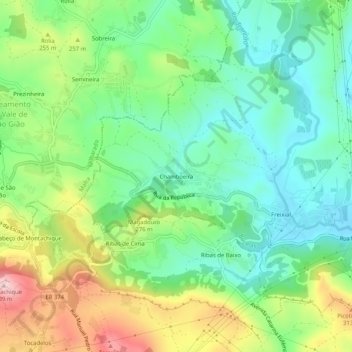
Name: Chamboeira topographic map, elevation, terrain.
Location: Chamboeira, Bucelas, Loures, Lisboa, 2665-371, Portugal (38.89067 -9.18886 38.93067 -9.14886)
Average elevation: 666 ft
Minimum elevation: 322 ft
Maximum elevation: 1,309 ft
Thank you for supporting this site ❤️
Make a donation
Make a donation
Gear up for your next adventure:
As an Amazon Associate, this site earns from qualifying purchases at no extra cost to you.