
Thank you for supporting this site ❤️
Make a donation
Make a donation
Gear up for your next adventure:
As an Amazon Associate, this site earns from qualifying purchases at no extra cost to you.
Roing topographic map
Click on the map to display elevation.
Thank you for supporting this site ❤️
Make a donation
Make a donation
Gear up for your next adventure:
As an Amazon Associate, this site earns from qualifying purchases at no extra cost to you.
About this map
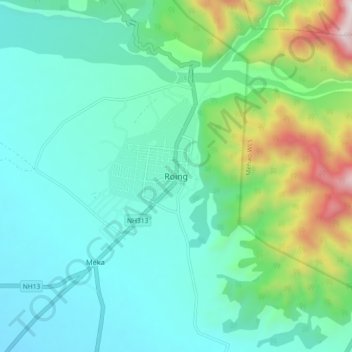
Name: Roing topographic map, elevation, terrain.
Location: Roing, Roing HQ, Lower Dibang Valley, Arunachal Pradesh, India (28.09685 95.80308 28.17685 95.88308)
Average elevation: 1,611 ft
Minimum elevation: 758 ft
Maximum elevation: 4,633 ft
Thank you for supporting this site ❤️
Make a donation
Make a donation
Gear up for your next adventure:
As an Amazon Associate, this site earns from qualifying purchases at no extra cost to you.