
Make a donation
Gear up for your next adventure:
As an Amazon Associate, this site earns from qualifying purchases at no extra cost to you.
Pulo di Altamura topographic map
Click on the map to display elevation.
Make a donation
Gear up for your next adventure:
As an Amazon Associate, this site earns from qualifying purchases at no extra cost to you.
Pulo di Altamura
Nelle prime carte topografiche dell'Istituto Geografico Militare (fine dell'Ottocento) il nome della località era riportato impropriamente come "Polo", ma tale trascrizione fu corretta nelle edizioni successive.
Make a donation
Gear up for your next adventure:
As an Amazon Associate, this site earns from qualifying purchases at no extra cost to you.
About this map
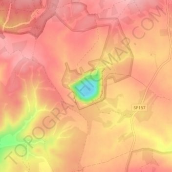
Name: Pulo di Altamura topographic map, elevation, terrain.
Location: Pulo di Altamura, Altamura, Bari, Puglia, Italia (40.88727 16.56404 40.89303 16.57187)
Average elevation: 1,568 ft
Minimum elevation: 1,260 ft
Maximum elevation: 1,670 ft
Make a donation
Gear up for your next adventure:
As an Amazon Associate, this site earns from qualifying purchases at no extra cost to you.