
Make a donation
Gear up for your next adventure:
As an Amazon Associate, this site earns from qualifying purchases at no extra cost to you.
Atur topographic map
Click on the map to display elevation.
Make a donation
Gear up for your next adventure:
As an Amazon Associate, this site earns from qualifying purchases at no extra cost to you.
About this map
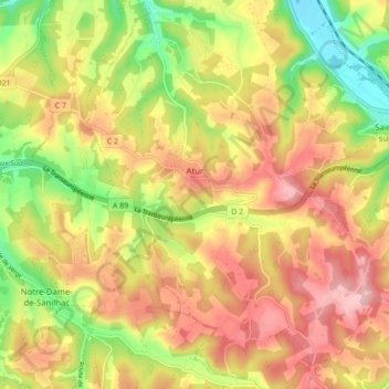
Name: Atur topographic map, elevation, terrain.
Average elevation: 630 ft
Minimum elevation: 308 ft
Maximum elevation: 902 ft
Make a donation
Gear up for your next adventure:
As an Amazon Associate, this site earns from qualifying purchases at no extra cost to you.
Other topographic maps
Click on a map to view its topography, its elevation and its terrain.
La Croix Bertrix
France > Nouvelle-Aquitaine > Dordogne > Boulazac Isle Manoire
Average elevation: 446 ft
Make a donation
Gear up for your next adventure:
As an Amazon Associate, this site earns from qualifying purchases at no extra cost to you.
Meyrinas
France > Nouvelle-Aquitaine > Dordogne > Boulazac Isle Manoire > Meyrinas
Average elevation: 564 ft