
Thank you for supporting this site ❤️
Make a donation
Make a donation
Gear up for your next adventure:
As an Amazon Associate, this site earns from qualifying purchases at no extra cost to you.
Moos topographic map
Click on the map to display elevation.
Thank you for supporting this site ❤️
Make a donation
Make a donation
Gear up for your next adventure:
As an Amazon Associate, this site earns from qualifying purchases at no extra cost to you.
About this map
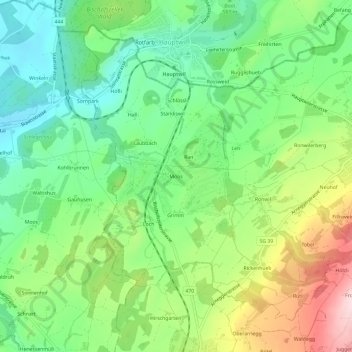
Name: Moos topographic map, elevation, terrain.
Location: Moos, Waldkirch, Wahlkreis St. Gallen, St. Gallen, 9213, Schweiz (47.44451 9.23192 47.48451 9.27192)
Average elevation: 1,962 ft
Minimum elevation: 1,627 ft
Maximum elevation: 2,549 ft
Thank you for supporting this site ❤️
Make a donation
Make a donation
Gear up for your next adventure:
As an Amazon Associate, this site earns from qualifying purchases at no extra cost to you.