Geolocate

Peppard Common topographic map

Click on the map to display elevation.

About this map

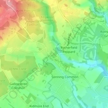
Name: Peppard Common topographic map, elevation, terrain.

Location: Peppard Common, Rotherfield Peppard, South Oxfordshire, Oxfordshire, England, RG9 5EH, United Kingdom (51.50806 -1.00642 51.54806 -0.96642)

Average elevation: 354 ft

Minimum elevation: 210 ft

Maximum elevation: 604 ft

Other topographic maps

Click on a map to view its topography, its elevation and its terrain.

Gear up for your next adventure:

🩹Survival Bandages - High‑quality bandages for emergencies
🚁Photography Drones - Capture stunning aerial views of landforms and topography
🧣Hiking Neck Gaiter - Multi‑use neck protection for outdoor weather
🌲Outdoor Survival Books - Best books on survival skills
🧭Compass with Lanyard - Easy‑carry compass for navigation

As an Amazon Associate, this site earns from qualifying purchases at no extra cost to you.