
Al Sir topographic map
Interactive map
Click on the map to display elevation.
About this map
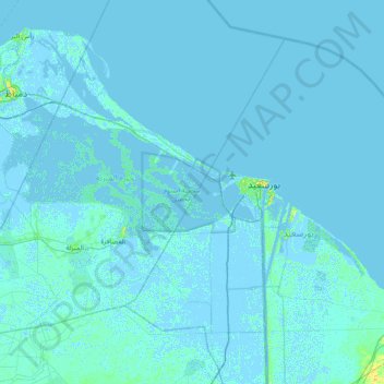
Name: Al Sir topographic map, elevation, terrain.
Location: Al Sir, Dakahlia Governorate, Egypt (30.93056 31.84556 31.57056 32.48556)
Average elevation: 0 ft
Minimum elevation: -16 ft
Maximum elevation: 69 ft
Other topographic maps
Click on a map to view its topography, its elevation and its terrain.
Sandub
Egypt > Dakahlia Governorate > Sandub
Sandub, Dakahlia Governorate, 35796, Egypt
Average elevation: 23 ft
Gideila
Egypt > Dakahlia Governorate > Mansoura > Gideila
Gideila, Mansoura, Dakahlia Governorate, 35524, Egypt
Average elevation: 23 ft
Az Zarqa
Egypt > Dakahlia Governorate > Az Zarqa
Az Zarqa, Dakahlia Governorate, 34724, Egypt
Average elevation: 10 ft