Geolocate

Arteche topographic map

Click on the map to display elevation.

About this map

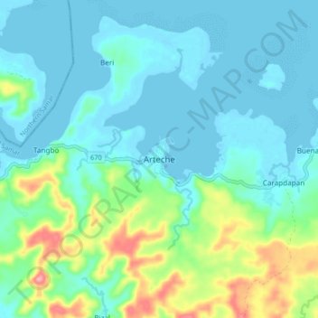
Name: Arteche topographic map, elevation, terrain.

Location: Arteche, Eastern Samar, Eastern Visayas, Philippines (12.22955 125.33131 12.30955 125.41131)

Average elevation: 79 ft

Minimum elevation: -3 ft

Maximum elevation: 364 ft

Other topographic maps

Click on a map to view its topography, its elevation and its terrain.

Borongan City

Philippines > Eastern Samar

Average elevation: 36 ft

Jipapad

Philippines > Eastern Samar

Average elevation: 361 ft

Hilabaan

Philippines > Eastern Samar

Average elevation: 3 ft

Tikling

Philippines > Eastern Samar

Average elevation: 0 ft

Homonhon Island

Philippines > Eastern Samar > Habag

Average elevation: 89 ft

Suluan Island

Philippines > Eastern Samar > Suluan

Average elevation: 39 ft

Manicani Island

Philippines > Eastern Samar > Banaag

Average elevation: 59 ft

Homonhon Island

Philippines > Eastern Samar > Culasi

Average elevation: 89 ft

Leleboon Island

Philippines > Eastern Samar > Sulangan

Average elevation: 13 ft

Oras

Philippines > Eastern Samar > Jipapad

Average elevation: 121 ft

Calicoan Island

Philippines > Eastern Samar > Ngolos

Average elevation: 13 ft

Homonhon Island

Philippines > Eastern Samar > Culasi

Average elevation: 89 ft

Gear up for your next adventure:

🧣Hiking Neck Gaiter - Multi‑use neck protection for outdoor weather
🩹Survival Bandages - High‑quality bandages for emergencies
👟Trail Running Shoes - Lightweight shoes for trail runners
📱Heavy-Duty Phone Cases - Drop-proof and waterproof protection for outdoor navigation
🧭Map Reading Tools - Tools and kits for map navigation

As an Amazon Associate, this site earns from qualifying purchases at no extra cost to you.