
Make a donation
Gear up for your next adventure:
As an Amazon Associate, this site earns from qualifying purchases at no extra cost to you.
Exeter Township topographic map
Click on the map to display elevation.
Make a donation
Gear up for your next adventure:
As an Amazon Associate, this site earns from qualifying purchases at no extra cost to you.
Exeter Township
According to the U.S. Census Bureau, the township has a total area of 24.6 square miles (64 km2), of which 24.4 square miles (63 km2) is land and 0.2 square miles (0.52 km2) (0.77%) is water. It is drained by the Schuylkill River, which forms its natural southern boundary. While areas closer to the river are low-lying, the northwestern area of the township is in the South Mountains and exceeds 250 metres (820 feet) at its highest elevation.
Make a donation
Gear up for your next adventure:
As an Amazon Associate, this site earns from qualifying purchases at no extra cost to you.
About this map
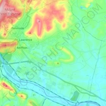
Name: Exeter Township topographic map, elevation, terrain.
Average elevation: 371 ft
Minimum elevation: 144 ft
Maximum elevation: 1,073 ft
Berks County trails, hiking, mountain biking, running and outdoor activities
Make a donation
Gear up for your next adventure:
As an Amazon Associate, this site earns from qualifying purchases at no extra cost to you.
Other topographic maps
Click on a map to view its topography, its elevation and its terrain.
Make a donation
Gear up for your next adventure:
As an Amazon Associate, this site earns from qualifying purchases at no extra cost to you.
11th and Pike Playground
United States > Pennsylvania > Berks County > Reading
Average elevation: 433 ft
Maple Grove Park
United States > Pennsylvania > Berks County > Brecknock Township
Average elevation: 650 ft
Make a donation
Gear up for your next adventure:
As an Amazon Associate, this site earns from qualifying purchases at no extra cost to you.
Morgantown
United States > Pennsylvania > Berks County > Caernarvon Township
Average elevation: 620 ft
Hawk Mountain
United States > Pennsylvania > Berks County > Windsor Township
Average elevation: 1,142 ft
Make a donation
Gear up for your next adventure:
As an Amazon Associate, this site earns from qualifying purchases at no extra cost to you.
Tulpehocken Creek
United States > Pennsylvania > Berks County > Penn Township > Pleasant Valley
Average elevation: 364 ft
Make a donation
Gear up for your next adventure:
As an Amazon Associate, this site earns from qualifying purchases at no extra cost to you.
Morgantown
United States > Pennsylvania > Berks County > Caernarvon Township
Average elevation: 620 ft
Hamburg Reservoir
United States > Pennsylvania > Berks County > Windsor Township
Average elevation: 1,112 ft
Make a donation
Gear up for your next adventure:
As an Amazon Associate, this site earns from qualifying purchases at no extra cost to you.
Morgantown
United States > Pennsylvania > Berks County > Caernarvon Township
Average elevation: 620 ft
Make a donation
Gear up for your next adventure:
As an Amazon Associate, this site earns from qualifying purchases at no extra cost to you.
Shartlesville
United States > Pennsylvania > Berks County > Upper Bern Township
Average elevation: 600 ft
Spring Ridge
United States > Pennsylvania > Berks County > Spring Township > Spring Ridge
Average elevation: 322 ft
Make a donation
Gear up for your next adventure:
As an Amazon Associate, this site earns from qualifying purchases at no extra cost to you.
Barto
United States > Pennsylvania > Berks County > Washington Township > Barto
Average elevation: 571 ft
Blue Marsh Bernville Levee
United States > Pennsylvania > Berks County > Bernville
Average elevation: 364 ft