
Make a donation
Gear up for your next adventure:
As an Amazon Associate, this site earns from qualifying purchases at no extra cost to you.
Aquia topographic map
Click on the map to display elevation.
Make a donation
Gear up for your next adventure:
As an Amazon Associate, this site earns from qualifying purchases at no extra cost to you.
About this map
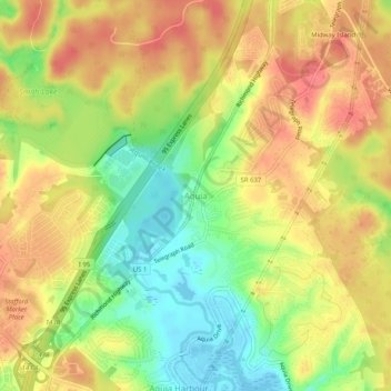
Name: Aquia topographic map, elevation, terrain.
Location: Aquia, Stafford County, Virginia, 22554, United States (38.46235 -77.40665 38.50235 -77.36665)
Average elevation: 128 ft
Minimum elevation: -16 ft
Maximum elevation: 233 ft
Make a donation
Gear up for your next adventure:
As an Amazon Associate, this site earns from qualifying purchases at no extra cost to you.
Other topographic maps
Click on a map to view its topography, its elevation and its terrain.
Southern Gateway
United States > Virginia > Stafford County > Southern Gateway
Average elevation: 240 ft
Make a donation
Gear up for your next adventure:
As an Amazon Associate, this site earns from qualifying purchases at no extra cost to you.
Boswell's Corner
United States > Virginia > Stafford County > Boswell's Corner
Average elevation: 154 ft
Make a donation
Gear up for your next adventure:
As an Amazon Associate, this site earns from qualifying purchases at no extra cost to you.