Geolocate

Andagna topographic map

Click on the map to display elevation.

About this map
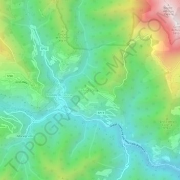
Name: Andagna topographic map, elevation, terrain.

Location: Andagna, Molini di Triora, Provincia di Imperia, Liguria, Italy (43.97136 7.76405 44.01136 7.80405)

Average elevation: 2,382 ft

Minimum elevation: 1,194 ft

Maximum elevation: 5,177 ft

Other topographic maps

Click on a map to view its topography, its elevation and its terrain.

Armo

Italy > Provincia di Imperia

Average elevation: 3,091 ft

Borgomaro

Italy > Provincia di Imperia

Average elevation: 1,755 ft

Pigna

Italy > Provincia di Imperia

Average elevation: 2,979 ft

Lucinasco

Italy > Provincia di Imperia

Average elevation: 1,325 ft

Gear up for your next adventure:

🔌Solar Panel Charger - Charge gear sustainably outdoors
🧦Merino Wool Socks - Moisture-wicking, blister-preventing socks for long treks
🔭Stargazing Telescopes - Perfect for camping in low-light pollution areas shown on maps
🧤Hiking Gloves - Protective gloves for rugged trails
🥤Water Filter Bottle - All‑in‑one filter bottle for safe hydration

As an Amazon Associate, this site earns from qualifying purchases at no extra cost to you.