Geolocate

Tamparuli topographic map

Click on the map to display elevation.

About this map

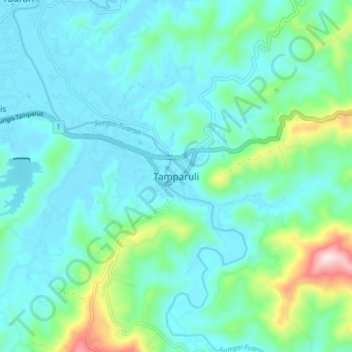
Name: Tamparuli topographic map, elevation, terrain.

Location: Tamparuli, Tuaran, West Coast Division, Sabah, 89257, Malaysia (6.09581 116.22896 6.17581 116.30896)

Average elevation: 315 ft

Minimum elevation: 16 ft

Maximum elevation: 1,657 ft

Gear up for your next adventure:

🔦Powerful Headlamps - Ultra-bright hands-free lighting for night navigation
📡Handheld GPS Device - Reliable handheld GPS for outdoor navigation
🗺️NatGeo Topo Maps - High-quality waterproof printed topographic maps of US Parks
🥤Water Filter Bottle - All‑in‑one filter bottle for safe hydration
📌Outdoor GPS Map App - Apps and devices for digital topographic navigation

As an Amazon Associate, this site earns from qualifying purchases at no extra cost to you.