Geolocate

Bilston topographic map

Click on the map to display elevation.

About this map

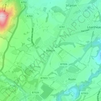
Name: Bilston topographic map, elevation, terrain.

Location: Bilston, Midlothian, Scotland, EH25 9SH, United Kingdom (55.84874 -3.19988 55.88874 -3.15988)

Average elevation: 554 ft

Minimum elevation: 276 ft

Maximum elevation: 1,476 ft

Gear up for your next adventure:

🚑Emergency Bivvies - Heat-reflective sleeping bags for survival situations
📷Action Camera - Capture your outdoor adventures in HD
📚USA Hiking Guide Books - Top trail guides and map books
🦶Hiking Gaiters - Keep debris and water out of your boots
🏥Hiking First Aid Kits - Comprehensive medical kits for remote trail injuries

As an Amazon Associate, this site earns from qualifying purchases at no extra cost to you.