
Make a donation
Gear up for your next adventure:
As an Amazon Associate, this site earns from qualifying purchases at no extra cost to you.
Digne-les-Bains topographic map
Click on the map to display elevation.
Make a donation
Gear up for your next adventure:
As an Amazon Associate, this site earns from qualifying purchases at no extra cost to you.
Digne-les-Bains
Digne-les-Bains is the capital of the Department of Alpes de Haute-Provence. Placed in the geographical centre of the Department, the commune is home to 17,400 inhabitants, making it one of the smaller prefectures of France by its population. The town centre is at 608 metres (1,995 ft) altitude.
Make a donation
Gear up for your next adventure:
As an Amazon Associate, this site earns from qualifying purchases at no extra cost to you.
About this map
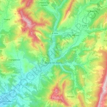
Name: Digne-les-Bains topographic map, elevation, terrain.
Average elevation: 2,851 ft
Minimum elevation: 1,644 ft
Maximum elevation: 5,476 ft
Make a donation
Gear up for your next adventure:
As an Amazon Associate, this site earns from qualifying purchases at no extra cost to you.