
Washington Township topographic map
Interactive map
Click on the map to display elevation.
About this map
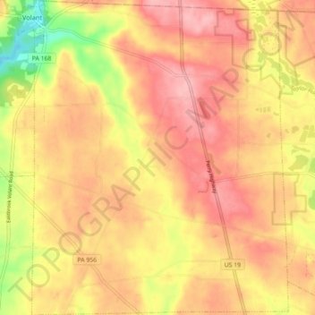
Name: Washington Township topographic map, elevation, terrain.
Average elevation: 1,250 ft
Minimum elevation: 994 ft
Maximum elevation: 1,394 ft
Lawrence County trails, hiking, mountain biking, running and outdoor activities
Other topographic maps
Click on a map to view its topography, its elevation and its terrain.
Duckrun
United States > Pennsylvania > Lawrence County > Shenango Township
Average elevation: 1,217 ft
East New Castle
United States > Pennsylvania > Lawrence County > Shenango Township
Average elevation: 1,043 ft
Plain Grove
United States > Pennsylvania > Lawrence County > Plain Grove Township
Average elevation: 1,181 ft
Fayette
United States > Pennsylvania > Lawrence County > Wilmington Township
Average elevation: 1,056 ft