
Make a donation
Gear up for your next adventure:
As an Amazon Associate, this site earns from qualifying purchases at no extra cost to you.
Kennesaw Mountain topographic map
Click on the map to display elevation.
Make a donation
Gear up for your next adventure:
As an Amazon Associate, this site earns from qualifying purchases at no extra cost to you.
Kennesaw Mountain
Kennesaw Mountain is a mountain between Marietta and Kennesaw, Georgia in the United States with a summit elevation of 1,808 feet (551 m). It is the highest point in the core (urban and suburban) metro Atlanta area, and fifth after further-north exurban counties are considered. The local terrain averages roughly 1,000 feet (300 m) AMSL.
Make a donation
Gear up for your next adventure:
As an Amazon Associate, this site earns from qualifying purchases at no extra cost to you.
About this map
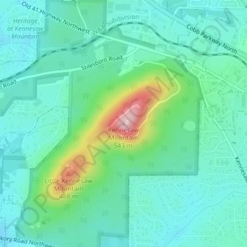
Name: Kennesaw Mountain topographic map, elevation, terrain.
Average elevation: 1,181 ft
Minimum elevation: 1,017 ft
Maximum elevation: 1,745 ft
Cobb County trails, hiking, mountain biking, running and outdoor activities
Make a donation
Gear up for your next adventure:
As an Amazon Associate, this site earns from qualifying purchases at no extra cost to you.
Other topographic maps
Click on a map to view its topography, its elevation and its terrain.
Make a donation
Gear up for your next adventure:
As an Amazon Associate, this site earns from qualifying purchases at no extra cost to you.