
Thank you for supporting this site ❤️
Make a donation
Make a donation
Gear up for your next adventure:
As an Amazon Associate, this site earns from qualifying purchases at no extra cost to you.
Bichhri topographic map
Click on the map to display elevation.
Thank you for supporting this site ❤️
Make a donation
Make a donation
Gear up for your next adventure:
As an Amazon Associate, this site earns from qualifying purchases at no extra cost to you.
About this map
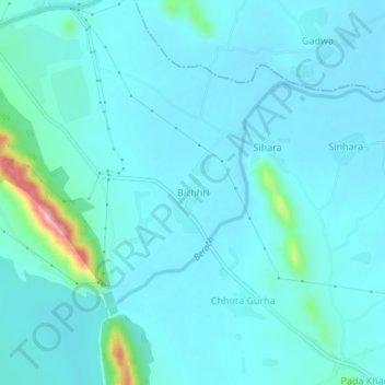
Name: Bichhri topographic map, elevation, terrain.
Location: Bichhri, Girwa Tehsil, Udaipur District, Rajasthan, India (24.57024 73.81484 24.61024 73.85484)
Average elevation: 1,791 ft
Minimum elevation: 1,709 ft
Maximum elevation: 2,418 ft
Thank you for supporting this site ❤️
Make a donation
Make a donation
Gear up for your next adventure:
As an Amazon Associate, this site earns from qualifying purchases at no extra cost to you.