Geolocate

Flöha topographic map

Click on the map to display elevation.

About this map

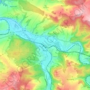
Name: Flöha topographic map, elevation, terrain.

Location: Flöha, Mittelsachsen, Saxony, 09557, Germany (50.82937 13.03242 50.87997 13.14133)

Average elevation: 1,178 ft

Minimum elevation: 853 ft

Maximum elevation: 1,634 ft

Other topographic maps

Click on a map to view its topography, its elevation and its terrain.

Clausnitz

Germany > Saxony > Mittelsachsen

Average elevation: 1,998 ft

Holzhau

Germany > Saxony > Mittelsachsen

Average elevation: 2,379 ft

Seifersdorf

Germany > Saxony > Mittelsachsen > Hartha

Average elevation: 814 ft

Tuttendorf

Germany > Saxony > Mittelsachsen

Average elevation: 1,234 ft

Dittmannsdorf

Germany > Saxony > Mittelsachsen > Penig

Average elevation: 820 ft

Erdmannsdorf

Germany > Saxony > Mittelsachsen > Augustusburg

Average elevation: 1,234 ft

Hühnerberg

Germany > Saxony > Mittelsachsen > Leisnig

Average elevation: 686 ft

Gear up for your next adventure:

🌄Hiking Binoculars - Compact binoculars for scenic views and trail spotting
🧤Hiking Gloves - Protective gloves for rugged trails
🧭GPS Watch Accessories - Bands and chargers for GPS watches
🏥Hiking First Aid Kits - Comprehensive medical kits for remote trail injuries
🧺Microfiber Travel Towels - Compact and fast-drying towels for trail use

As an Amazon Associate, this site earns from qualifying purchases at no extra cost to you.