Geolocate

Torquay topographic map

Click on the map to display elevation.

About this map
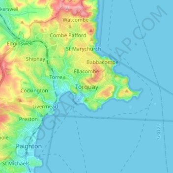
Name: Torquay topographic map, elevation, terrain.

Location: Torquay, Torbay, Devon and Torbay, England, TQ1 1TR, United Kingdom (50.42524 -3.56114 50.50524 -3.48114)

Average elevation: 102 ft

Minimum elevation: -7 ft

Maximum elevation: 584 ft

Other topographic maps

Click on a map to view its topography, its elevation and its terrain.

Brixham

United Kingdom > England > Torbay

Average elevation: 125 ft

Brixham

United Kingdom > England > Torbay

Average elevation: 125 ft

Brixham

United Kingdom > England > Torbay

Average elevation: 125 ft

Gear up for your next adventure:

📡Handheld GPS Device - Reliable handheld GPS for outdoor navigation
🧥Waterproof Jacket for Hiking - Breathable and rugged rain jacket for outdoor excursions
🦺Reflective Outdoor Gear - Safety gear for low‑light conditions
🪑Ultralight Camp Chairs - Portable seating for resting after a long day of mapping
🕶️GPS Smartphone Mount - Secure mount for phone navigation

As an Amazon Associate, this site earns from qualifying purchases at no extra cost to you.