
Thank you for supporting this site ❤️
Make a donation
Make a donation
Gear up for your next adventure:
As an Amazon Associate, this site earns from qualifying purchases at no extra cost to you.
Kohir topographic map
Click on the map to display elevation.
Thank you for supporting this site ❤️
Make a donation
Make a donation
Gear up for your next adventure:
As an Amazon Associate, this site earns from qualifying purchases at no extra cost to you.
Kohir
Kohir is located at 17°36′00″N 77°43′00″E / 17.6000°N 77.7167°E / 17.6000; 77.7167. It has an average elevation of 627 metres (2060 ft). It is 100 km from Hyderabad, 53 km from Bidar and 21 km from Zaheerabad.
Thank you for supporting this site ❤️
Make a donation
Make a donation
Gear up for your next adventure:
As an Amazon Associate, this site earns from qualifying purchases at no extra cost to you.
About this map
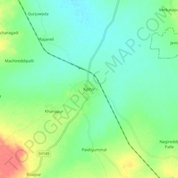
Name: Kohir topographic map, elevation, terrain.
Average elevation: 2,080 ft
Minimum elevation: 2,024 ft
Maximum elevation: 2,195 ft
Thank you for supporting this site ❤️
Make a donation
Make a donation
Gear up for your next adventure:
As an Amazon Associate, this site earns from qualifying purchases at no extra cost to you.