
Thank you for supporting this site ❤️
Make a donation
Make a donation
Gear up for your next adventure:
As an Amazon Associate, this site earns from qualifying purchases at no extra cost to you.
Hamsiköy topographic map
Click on the map to display elevation.
Thank you for supporting this site ❤️
Make a donation
Make a donation
Gear up for your next adventure:
As an Amazon Associate, this site earns from qualifying purchases at no extra cost to you.
About this map
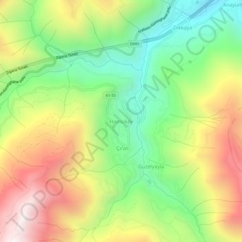
Name: Hamsiköy topographic map, elevation, terrain.
Location: Hamsiköy, Maçka, Trabzon, Black Sea Region, Turkey (40.66759 39.46219 40.70759 39.50219)
Average elevation: 4,820 ft
Minimum elevation: 3,035 ft
Maximum elevation: 7,087 ft
Thank you for supporting this site ❤️
Make a donation
Make a donation
Gear up for your next adventure:
As an Amazon Associate, this site earns from qualifying purchases at no extra cost to you.