
Quebrada Topara topographic map
Click on the map to display elevation.
About this map
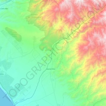
Name: Quebrada Topara topographic map, elevation, terrain.
Location: Quebrada Topara, Provincia de Cañete, Lima, Perú (-13.32422 -76.24523 -13.09430 -76.01989)
Average elevation: 2,119 ft
Minimum elevation: 0 ft
Maximum elevation: 6,296 ft
Other topographic maps
Click on a map to view its topography, its elevation and its terrain.
San Vicente de Cañete
Perú > Lima > San Vicente de Cañete
La ciudad de San Vicente de Cañete se encuentra a 144 km de la ciudad de Lima, a orillas del río Cañete, a una altitud de 40 msnm.
Average elevation: 577 ft
San Vicente de Cañete
Perú > Lima > San Vicente de Cañete
La ciudad de San Vicente de Cañete se encuentra a 144 km de la ciudad de Lima, a orillas del río Cañete, a una altitud de 40 m s. n. m.
Average elevation: 154 ft