
Egremont topographic map
Click on the map to display elevation.
About this map
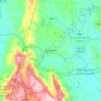
Name: Egremont topographic map, elevation, terrain.
Location: Egremont, Berkshire County, Massachusetts, United States (42.11815 -73.48309 42.21754 -73.38831)
Average elevation: 1,007 ft
Minimum elevation: 617 ft
Maximum elevation: 2,028 ft
Berkshire County trails, hiking, mountain biking, running and outdoor activities
Other topographic maps
Click on a map to view its topography, its elevation and its terrain.
Mount Everett
United States > Massachusetts > Berkshire County
Mount Everett helps divide the watersheds of the Hudson and Housatonic rivers. Its eastern slopes share a larger escarpment with Mount Race and Bear Mountain plus several related summits. This escarpment rises from an elevation around 700 feet in Sheffield's Housatonic Valley at a mean angle of about 20…
Average elevation: 1,841 ft
Hephzibah Heights
United States > Massachusetts > Berkshire County > Monterey
Average elevation: 1,499 ft
Mount Greylock
United States > Massachusetts > Berkshire County > Adams
Geographically, Mount Greylock is part of an 11-mile-long (18 km) by 4+1⁄2-mile-wide (7 km) island-like range that runs north-south between the Hoosac Range to the east, the Green Mountains to the north, the Berkshires to both the south and east, and the Taconic Mountains to the west with which it is…
Average elevation: 2,448 ft
Southfield
United States > Massachusetts > Berkshire County > New Marlborough
Average elevation: 1,329 ft
Brayton Hill
United States > Massachusetts > Berkshire County > North Adams
Average elevation: 1,053 ft
Berkshire Heights
United States > Massachusetts > Berkshire County > Great Barrington
Average elevation: 797 ft
Rockdale Mills
United States > Massachusetts > Berkshire County > West Stockbridge
Average elevation: 1,093 ft
New Marlborough Village
United States > Massachusetts > Berkshire County > New Marlborough
Average elevation: 1,404 ft
Pittsfield
United States > Massachusetts > Berkshire County
Pittsfield has a humid continental climate (Dfb). Winters are harsh due the city's high elevation at 1,039 ft (317 m), with an average annual snowfall of 75.9 inches (1,930 mm) and temperatures dipping to 0 °F (−18 °C) or colder 13 times per year. Summers, however, are typically warm and pleasant, with…
Average elevation: 1,421 ft
Mount Greylock
United States > Massachusetts > Berkshire County > Adams
Northern hardwood forest characterize lower and mid-elevations, while upper slopes are covered with balsam fir and red spruce as well as American mountain ash. About 555 acres (225 hectares) of old growth forest have been inventoried within the Greylock Range, including tree specimens up to 350 years old. On…
Average elevation: 2,448 ft
Yankee Orchards
United States > Massachusetts > Berkshire County > Pittsfield
Average elevation: 1,129 ft
Brookside
United States > Massachusetts > Berkshire County > Great Barrington
Average elevation: 932 ft
Clover Hill Farm Conservation Area
United States > Massachusetts > Berkshire County > Williamstown > Meadowvale
Average elevation: 712 ft
State Line
United States > Massachusetts > Berkshire County > West Stockbridge
Average elevation: 1,129 ft
Greylock
United States > Massachusetts > Berkshire County > North Adams > Greylock
Average elevation: 1,030 ft
Bonny Rigg Corners
United States > Massachusetts > Berkshire County > Becket
Average elevation: 1,476 ft
Risingdale
United States > Massachusetts > Berkshire County > Great Barrington
Average elevation: 909 ft
Housatonic
United States > Massachusetts > Berkshire County > Great Barrington
Average elevation: 955 ft
Richmond Pond
United States > Massachusetts > Berkshire County > Richmond > Camp Russell
Average elevation: 1,158 ft
Mount Frissell
United States > Massachusetts > Berkshire County > Mount Washington
Average elevation: 2,014 ft
March Cataract Falls
United States > Massachusetts > Berkshire County > Williamstown
Average elevation: 2,510 ft
Mountain Meadow Preserve
United States > Massachusetts > Berkshire County > Williamstown
Average elevation: 876 ft