
Mount Greylock topographic map
Click on the map to display elevation.
Mount Greylock
Geographically, Mount Greylock is part of an 11-mile-long (18 km) by 4+1⁄2-mile-wide (7 km) island-like range that runs north-south between the Hoosac Range to the east, the Green Mountains to the north, the Berkshires to both the south and east, and the Taconic Mountains to the west with which it is geologically associated; all ranges are associated with the Appalachian mountain chain. The summit of Mount Greylock is located in Adams, Massachusetts, but the mountain also extends into Cheshire, Lanesborough, New Ashford, North Adams and Williamstown. The range includes peaks with elevation less than Greylock, such as Saddle Ball Mountain and Mount Fitch.
About this map
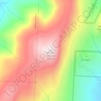
Name: Mount Greylock topographic map, elevation, terrain.
Average elevation: 2,448 ft
Minimum elevation: 1,266 ft
Maximum elevation: 3,484 ft
Berkshire County trails, hiking, mountain biking, running and outdoor activities