
Thank you for supporting this site ❤️
Make a donation
Make a donation
Gear up for your next adventure:
As an Amazon Associate, this site earns from qualifying purchases at no extra cost to you.
Little Axe topographic map
Click on the map to display elevation.
Thank you for supporting this site ❤️
Make a donation
Make a donation
Gear up for your next adventure:
As an Amazon Associate, this site earns from qualifying purchases at no extra cost to you.
About this map
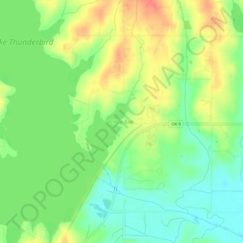
Name: Little Axe topographic map, elevation, terrain.
Average elevation: 1,053 ft
Minimum elevation: 971 ft
Maximum elevation: 1,155 ft
Thank you for supporting this site ❤️
Make a donation
Make a donation
Gear up for your next adventure:
As an Amazon Associate, this site earns from qualifying purchases at no extra cost to you.
Other topographic maps
Click on a map to view its topography, its elevation and its terrain.
Lake Thunderbird
United States > Oklahoma > Cleveland County > Norman > Little Axe
Average elevation: 1,096 ft
Sutton Urban Wilderness Park
United States > Oklahoma > Cleveland County > Norman
Average elevation: 1,198 ft