

Cozes topographic map
Click on the map to display elevation.
About this map
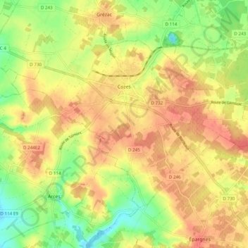
Name: Cozes topographic map, elevation, terrain.
Average elevation: 118 ft
Minimum elevation: 7 ft
Maximum elevation: 197 ft
Other topographic maps
Click on a map to view its topography, its elevation and its terrain.


Fief des Chênes
France > Nouvelle-Aquitaine > Charente-Maritime > La Rochelle
Average elevation: 13 ft
Fief des Chênes
France > Nouvelle-Aquitaine > Charente-Maritime > La Rochelle
Average elevation: 13 ft

Fief des Chênes
France > Nouvelle-Aquitaine > Charente-Maritime > La Rochelle
Average elevation: 13 ft

La Pimpevinière
France > Nouvelle-Aquitaine > Charente-Maritime > Marennes-Hiers-Brouage
Average elevation: 23 ft

La Chataignerie
France > Nouvelle-Aquitaine > Charente-Maritime > Plassay > Conchamp
Average elevation: 167 ft
Pièce du Moulin
France > Nouvelle-Aquitaine > Charente-Maritime > Le Grand-Village-Plage
Average elevation: 13 ft




Marennes-Plage
France > Nouvelle-Aquitaine > Charente-Maritime > Marennes-Hiers-Brouage
Average elevation: 10 ft
Le Moulin de Dore
France > Nouvelle-Aquitaine > Charente-Maritime > Barzan-Plage > Chez Pilou
Average elevation: 30 ft
Le Pérat
France > Nouvelle-Aquitaine > Charente-Maritime > Saint-Bonnet-sur-Gironde
Average elevation: 62 ft
Barbeau
France > Nouvelle-Aquitaine > Charente-Maritime > Bernay-Saint-Martin
Average elevation: 161 ft
