
Libertas topographic map
Click on the map to display elevation.
About this map
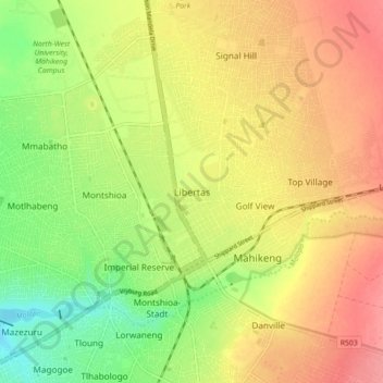
Name: Libertas topographic map, elevation, terrain.
Average elevation: 4,216 ft
Minimum elevation: 4,078 ft
Maximum elevation: 4,331 ft
Other topographic maps
Click on a map to view its topography, its elevation and its terrain.
Mahikeng Ward 24
South Africa > North West > Ngaka Modiri Molema District Municipality > Mahikeng Local Municipality
Average elevation: 4,469 ft
Mafikeng Game Reserve
South Africa > North West > Ngaka Modiri Molema District Municipality > Mahikeng Local Municipality
Average elevation: 4,386 ft
Lotlamoreng Dam
South Africa > North West > Ngaka Modiri Molema District Municipality > Mahikeng Local Municipality > Seweding
Average elevation: 4,121 ft