Geolocate

Mendefera topographic map

Click on the map to display elevation.

About this map

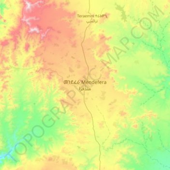
Name: Mendefera topographic map, elevation, terrain.

Location: Mendefera, Debub Region, Eritrea (14.72412 38.65294 15.04412 38.97294)

Average elevation: 6,129 ft

Minimum elevation: 4,665 ft

Maximum elevation: 8,366 ft

Other topographic maps

Click on a map to view its topography, its elevation and its terrain.

Ma'ereba

Eritrea > Debub Region

Average elevation: 6,890 ft

Mereb river

Eritrea > Debub Region

Average elevation: 4,646 ft

Mereb river ሩባ መረብ

Eritrea > Debub Region

Average elevation: 4,774 ft

Gear up for your next adventure:

🏔️Mountain Trail Maps - High‑detail maps for popular peaks
🛡️Bear Spray Outdoor - Protection in bear country hikes
❄️Traction Cleats - Prevent slips on icy trails during winter hikes
🗺️Topographic Maps - Detailed topo maps for hiking, exploring and outdoor navigation
🪓Survival Multi‑Tool - Versatile tool for camp and trail tasks

As an Amazon Associate, this site earns from qualifying purchases at no extra cost to you.