Geolocate

Shell Island topographic map

Click on the map to display elevation.

About this map

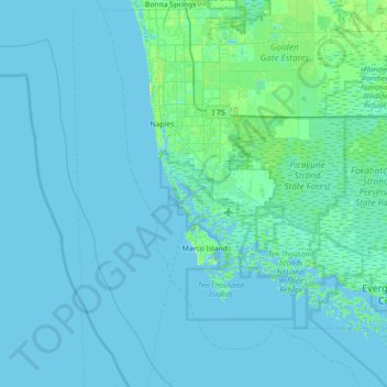
Name: Shell Island topographic map, elevation, terrain.

Location: Shell Island, Collier County, Florida, United States (25.70537 -82.05592 26.34537 -81.41592)

Average elevation: 7 ft

Minimum elevation: -10 ft

Maximum elevation: 85 ft

Collier County trails, hiking, mountain biking, running and outdoor activities

Other topographic maps

Click on a map to view its topography, its elevation and its terrain.

Vineyards

United States > Florida > Collier County

Average elevation: 20 ft

Orangetree

United States > Florida > Collier County

Average elevation: 20 ft

Goodland

United States > Florida > Collier County

Average elevation: 7 ft

Golden Gate

United States > Florida > Collier County

Average elevation: 16 ft

Pine Ridge

United States > Florida > Collier County

Average elevation: 23 ft

Ave Maria

United States > Florida > Collier County

Average elevation: 26 ft

Rock Creek

United States > Florida > Collier County > Naples

Average elevation: 16 ft

Baker Park

United States > Florida > Collier County > Naples

Average elevation: 16 ft

Naples Manor

United States > Florida > Collier County

Average elevation: 16 ft

Gear up for your next adventure:

🛰️Handheld GPS Units - Professional satellite navigators for precise backcountry mapping
🥤Water Filter Bottle - All‑in‑one filter bottle for safe hydration
🍳Camping Cook Set - Complete cookware for outdoor meals
🚁Photography Drones - Capture stunning aerial views of landforms and topography
⛑️Personal Locator Beacon - Safety beacon for emergencies

As an Amazon Associate, this site earns from qualifying purchases at no extra cost to you.