
Make a donation
Gear up for your next adventure:
As an Amazon Associate, this site earns from qualifying purchases at no extra cost to you.
Corleone topographic map
Click on the map to display elevation.
Make a donation
Gear up for your next adventure:
As an Amazon Associate, this site earns from qualifying purchases at no extra cost to you.
Corleone
Along the road that connects Corleone with Ficuzza, following the old railway line connecting Palermo to San Carlo (a hamlet of Chiusa Sclafani) (now the bike path), is an old bridge where the Frattina River streams between the limestone rocks. The erosive action of water has produced karst topography over time forming chasms, reels and small waterfalls where the abundant water first disappears and then reappears in the boulders and lush vegetation. Of considerable size are the "pots of the Giants", i.e. cylindrical and deep holes where the water takes on a swirling pattern. Old mulberry trees, oranges, pomegranates, and figs are living testimony of the site where a mill once stood. In the section where the slope is gentler, clear water pools have formed allowing visitors to bathe surrounded by bracken, maidenhair ferns, willows and elms, in the company of tortoise, fish, and colorful dragonflies. The walls that enclose the slopes are clad in rock plants of great botanical interest such as wood spurge, cabbage mountain, the carnation, and capers. Among the crevices of the rock shelter are pigeons, jackdaws, and birds of prey such as kestrels and the peregrine falcon. Tours take visitors up to the top of the gorge where the Frattina River continues to flow, in a more gentle manner, down to the Belice.
Make a donation
Gear up for your next adventure:
As an Amazon Associate, this site earns from qualifying purchases at no extra cost to you.
About this map
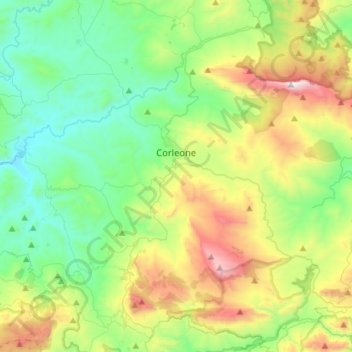
Name: Corleone topographic map, elevation, terrain.
Location: Corleone, Palermo, Sicily, 90034, Italy (37.70944 13.17797 37.88445 13.46276)
Average elevation: 2,051 ft
Minimum elevation: 666 ft
Maximum elevation: 5,246 ft
Make a donation
Gear up for your next adventure:
As an Amazon Associate, this site earns from qualifying purchases at no extra cost to you.
Other topographic maps
Click on a map to view its topography, its elevation and its terrain.
Make a donation
Gear up for your next adventure:
As an Amazon Associate, this site earns from qualifying purchases at no extra cost to you.