Geolocate

Carlson Lake topographic map

Click on the map to display elevation.

About this map

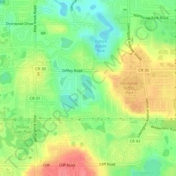
Name: Carlson Lake topographic map, elevation, terrain.

Location: Carlson Lake, Eagan, Dakota County, Minnesota, United States (44.79986 -93.15721 44.80407 -93.15407)

Average elevation: 919 ft

Minimum elevation: 810 ft

Maximum elevation: 1,043 ft

Dakota County trails, hiking, mountain biking, running and outdoor activities

Gear up for your next adventure:

🎒Trail Energy Bars - High‑calorie bars for hiking energy
📶Satellite Messenger - Communication device off‑grid
🔌USB Car Charger - Car charger for on‑the‑go power needs
🛏️Cold Weather Sleeping Bag - Warm sleeping bag for cold conditions
🎒Day Hiking Backpack - Lightweight backpack perfect for day trips and outdoor adventures

As an Amazon Associate, this site earns from qualifying purchases at no extra cost to you.