Geolocate

Uchuya topographic map

Click on the map to display elevation.

About this map

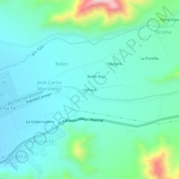
Name: Uchuya topographic map, elevation, terrain.

Location: Uchuya, Cantayo, Nasca, Ica, 11401, Perú (-14.84423 -74.93045 -14.80423 -74.89045)

Average elevation: 2,254 ft

Minimum elevation: 1,959 ft

Maximum elevation: 3,488 ft

Gear up for your next adventure:

🛡️Insect Repellent - Protection against bugs during outdoor activities
🌎3D Topographic Globes - Raised relief globes for a tactile understanding of geography
Solar GPS Watches - Advanced multisport watches with built-in topographic maps
📱Heavy-Duty Phone Cases - Drop-proof and waterproof protection for outdoor navigation
🚗GPS Dash Cams - Record your scenic drives through mountain passes and canyons

As an Amazon Associate, this site earns from qualifying purchases at no extra cost to you.