Geolocate

Tawid topographic map

Click on the map to display elevation.

About this map

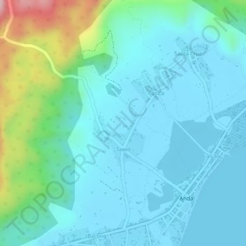
Name: Tawid topographic map, elevation, terrain.

Location: Tawid, Anda, Bohol, Central Visayas, Philippines (9.74392 124.55711 9.76027 124.57387)

Average elevation: 180 ft

Minimum elevation: 0 ft

Maximum elevation: 902 ft

Gear up for your next adventure:

🪶Thermal Camp Blanket - Extra warmth for cold nights
🔋Solar Power Banks - Keep your GPS and phone charged in remote wilderness areas
🥩Freeze-Dried Meals - Nutritious and lightweight food for remote expeditions
🪶Compact Camp Shovel - Folding shovel for campsite tasks
📦Gear Storage Bags - Organize and protect outdoor equipment

As an Amazon Associate, this site earns from qualifying purchases at no extra cost to you.