
Hochheim topographic map
Interactive map
Click on the map to display elevation.
About this map
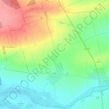
Name: Hochheim topographic map, elevation, terrain.
Location: Hochheim, Nessetal, Landkreis Gotha, Thüringen, Deutschland (51.00570 10.63856 51.04261 10.67943)
Average elevation: 981 ft
Minimum elevation: 850 ft
Maximum elevation: 1,175 ft
Im nördlichen Teil des Gothaer Landes, im Städte-Dreieck zwischen Gotha, Bad Langensalza und Erfurt, befindet sich im fruchtbaren Nessetal die Gemeinde Hochheim. Der Ort liegt nahe der Bundesstraße 247 an den südlichen Ausläufern des Hainichs in etwa 269 bis 290 m Höhe ü. NN. Die Nachbarorte sind im Süden Goldbach, Westhausen im Osten, Wangenheim im Westen und Wiegleben im Norden.
Other topographic maps
Click on a map to view its topography, its elevation and its terrain.
Goldbach
Deutschland > Thüringen > Landkreis Gotha > Nessetal
Goldbach, Nessetal, Landkreis Gotha, Thüringen, Deutschland
Average elevation: 984 ft
Ballstädt
Deutschland > Thüringen > Landkreis Gotha > Nessetal
Ballstädt, Nessetal, Landkreis Gotha, Thüringen, Deutschland
Average elevation: 942 ft
Wangenheim
Deutschland > Thüringen > Landkreis Gotha > Nessetal
Wangenheim, Nessetal, Landkreis Gotha, Thüringen, Deutschland
Average elevation: 981 ft