
Thank you for supporting this site ❤️
Make a donation
Make a donation
Gear up for your next adventure:
As an Amazon Associate, this site earns from qualifying purchases at no extra cost to you.
Pusuk topographic map
Click on the map to display elevation.
Thank you for supporting this site ❤️
Make a donation
Make a donation
Gear up for your next adventure:
As an Amazon Associate, this site earns from qualifying purchases at no extra cost to you.
About this map
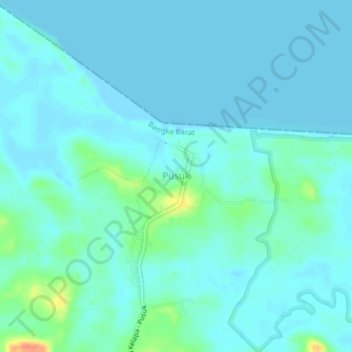
Name: Pusuk topographic map, elevation, terrain.
Location: Pusuk, Bangka Barat, Bangka-Belitung Islands, Indonesia (-1.80809 105.68193 -1.76809 105.72193)
Average elevation: 23 ft
Minimum elevation: -3 ft
Maximum elevation: 154 ft
Thank you for supporting this site ❤️
Make a donation
Make a donation
Gear up for your next adventure:
As an Amazon Associate, this site earns from qualifying purchases at no extra cost to you.