
Make a donation
Gear up for your next adventure:
As an Amazon Associate, this site earns from qualifying purchases at no extra cost to you.
Couzeix topographic map
Click on the map to display elevation.
Make a donation
Gear up for your next adventure:
As an Amazon Associate, this site earns from qualifying purchases at no extra cost to you.
About this map
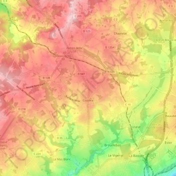
Name: Couzeix topographic map, elevation, terrain.
Average elevation: 1,158 ft
Minimum elevation: 728 ft
Maximum elevation: 1,437 ft
Make a donation
Gear up for your next adventure:
As an Amazon Associate, this site earns from qualifying purchases at no extra cost to you.
Other topographic maps
Click on a map to view its topography, its elevation and its terrain.
Puy Chaffrat
France > Nouvelle-Aquitaine > Haute-Vienne > Les Grands-Chézeaux
Average elevation: 922 ft
Make a donation
Gear up for your next adventure:
As an Amazon Associate, this site earns from qualifying purchases at no extra cost to you.
Les Rieux Vieux
France > Nouvelle-Aquitaine > Haute-Vienne > Saint-Pardoux-le-Lac
Average elevation: 1,247 ft
La Guérite
France > Nouvelle-Aquitaine > Haute-Vienne > Maisonnais-sur-Tardoire
Average elevation: 814 ft
Moulin de la Locherie
France > Nouvelle-Aquitaine > Haute-Vienne > Oradour-Saint-Genest
Average elevation: 659 ft
Make a donation
Gear up for your next adventure:
As an Amazon Associate, this site earns from qualifying purchases at no extra cost to you.
Make a donation
Gear up for your next adventure:
As an Amazon Associate, this site earns from qualifying purchases at no extra cost to you.