
Make a donation
Gear up for your next adventure:
As an Amazon Associate, this site earns from qualifying purchases at no extra cost to you.
Asón topographic map
Click on the map to display elevation.
Make a donation
Gear up for your next adventure:
As an Amazon Associate, this site earns from qualifying purchases at no extra cost to you.
About this map
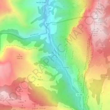
Name: Asón topographic map, elevation, terrain.
Location: Asón, Soba, Cantabria, 39806, España (43.20866 -3.62291 43.24866 -3.58291)
Average elevation: 2,569 ft
Minimum elevation: 656 ft
Maximum elevation: 4,573 ft
Make a donation
Gear up for your next adventure:
As an Amazon Associate, this site earns from qualifying purchases at no extra cost to you.
Other topographic maps
Click on a map to view its topography, its elevation and its terrain.
Parque Natural de los Collados del Asón
Se encuentra situado en plena cordillera Cantábrica al sudeste de Cantabria y la totalidad de su ámbito territorial, con una superficie de 4740 ha, 4020 ha pertenecientes al municipio de Soba y 720 Ha enclavadas en terreno privado, están en altitudes comprendidas entre los 240 y los 1632 m s. n. m.
Average elevation: 3,343 ft