
Make a donation
Gear up for your next adventure:
As an Amazon Associate, this site earns from qualifying purchases at no extra cost to you.
Repelón topographic map
Click on the map to display elevation.
Make a donation
Gear up for your next adventure:
As an Amazon Associate, this site earns from qualifying purchases at no extra cost to you.
Repelón
Repelón es un municipio del departamento del Atlántico, Colombia. Se encuentra al sudoeste del departamento marcando límites con el departamento de Bolívar. Fue fundado por Hilario Berrío el 25 de octubre de 1848. Su altitud es de 9 m s. n. m., temperatura promedio anual de 28 grados, tiene 350 km² y 86 km lo separan de Barranquilla, capital del departamento del Atlántico.
Make a donation
Gear up for your next adventure:
As an Amazon Associate, this site earns from qualifying purchases at no extra cost to you.
About this map
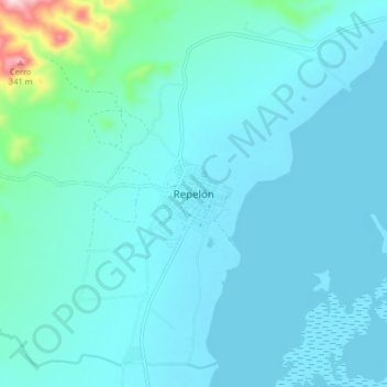
Name: Repelón topographic map, elevation, terrain.
Location: Repelón, Atlántico, Colombia (10.45501 -75.16448 10.53501 -75.08448)
Average elevation: 131 ft
Minimum elevation: 3 ft
Maximum elevation: 1,253 ft
Make a donation
Gear up for your next adventure:
As an Amazon Associate, this site earns from qualifying purchases at no extra cost to you.
Other topographic maps
Click on a map to view its topography, its elevation and its terrain.