
Make a donation
Gear up for your next adventure:
As an Amazon Associate, this site earns from qualifying purchases at no extra cost to you.
Trabada topographic map
Click on the map to display elevation.
Make a donation
Gear up for your next adventure:
As an Amazon Associate, this site earns from qualifying purchases at no extra cost to you.
About this map
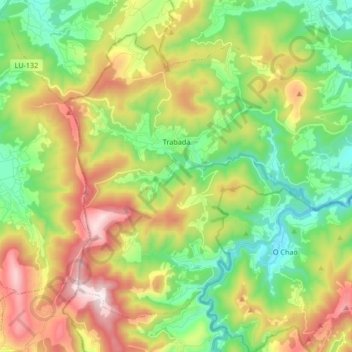
Name: Trabada topographic map, elevation, terrain.
Location: Trabada, Mariña Oriental, Lugo, Galicia, España (43.38581 -7.24778 43.48450 -7.08074)
Average elevation: 991 ft
Minimum elevation: 39 ft
Maximum elevation: 2,516 ft
Make a donation
Gear up for your next adventure:
As an Amazon Associate, this site earns from qualifying purchases at no extra cost to you.
Other topographic maps
Click on a map to view its topography, its elevation and its terrain.
Ribadeo
España > Galicia > Mariña Oriental
El relieve del municipio está definido por la costa cantábrica, donde destaca la playa de las Catedrales, la ría del Eo, el río Eo, que hace de límite con Vegadeo, y los montes interiores. La altitud oscila entre los 568 metros en el interior (Monte do Mondigo) y el nivel del mar. El pueblo se alza a 25…
Average elevation: 154 ft
Make a donation
Gear up for your next adventure:
As an Amazon Associate, this site earns from qualifying purchases at no extra cost to you.
Make a donation
Gear up for your next adventure:
As an Amazon Associate, this site earns from qualifying purchases at no extra cost to you.
Make a donation
Gear up for your next adventure:
As an Amazon Associate, this site earns from qualifying purchases at no extra cost to you.