
Make a donation
Gear up for your next adventure:
As an Amazon Associate, this site earns from qualifying purchases at no extra cost to you.
Toropalca topographic map
Click on the map to display elevation.
Make a donation
Gear up for your next adventure:
As an Amazon Associate, this site earns from qualifying purchases at no extra cost to you.
About this map
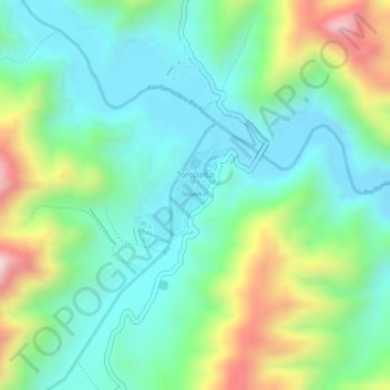
Name: Toropalca topographic map, elevation, terrain.
Average elevation: 9,295 ft
Minimum elevation: 8,871 ft
Maximum elevation: 10,190 ft
Make a donation
Gear up for your next adventure:
As an Amazon Associate, this site earns from qualifying purchases at no extra cost to you.
Other topographic maps
Click on a map to view its topography, its elevation and its terrain.
Tumusla
Bolivia > Potosí > Provincia Nor Chichas > Municipio Cotagaita
El pueblo está a una altitud de 2620 m s. n. m. a la derecha, margen sur del río Tumusla, que fluye sobre el río San Juan del Oro hasta el río Pilcomayo.
Average elevation: 8,911 ft
Tapchiquira
Bolivia > Potosí > Provincia Nor Chichas > Municipio Cotagaita
Average elevation: 10,253 ft
Santiago de Cotagaita
Bolivia > Potosí > Provincia Nor Chichas > Municipio Cotagaita
Average elevation: 9,108 ft
Make a donation
Gear up for your next adventure:
As an Amazon Associate, this site earns from qualifying purchases at no extra cost to you.
Santiago de Cotagaita
Bolivia > Potosí > Provincia Nor Chichas > Municipio Cotagaita
Average elevation: 9,108 ft