
Make a donation
Gear up for your next adventure:
As an Amazon Associate, this site earns from qualifying purchases at no extra cost to you.
Perlezzi topographic map
Click on the map to display elevation.
Make a donation
Gear up for your next adventure:
As an Amazon Associate, this site earns from qualifying purchases at no extra cost to you.
About this map
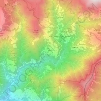
Name: Perlezzi topographic map, elevation, terrain.
Location: Perlezzi, Borzonasca, Genova, Liguria, 16041, Italia (44.42350 9.40011 44.46350 9.44011)
Average elevation: 2,375 ft
Minimum elevation: 564 ft
Maximum elevation: 4,206 ft
Make a donation
Gear up for your next adventure:
As an Amazon Associate, this site earns from qualifying purchases at no extra cost to you.
Other topographic maps
Click on a map to view its topography, its elevation and its terrain.
Lago di Giacopiane
Italia > Liguria > Genova > Borzonasca > Montemozzo
L'invaso è collocato a 1015 m di altitudine. Sottostante rispetto a questo lago se ne trova uno minore, denominato lago di Pian Sapeio. I due bacini sono collocati a gradino, il maggiore sopra al minore, per facilitare la caduta delle acque e sfruttare il salto per la produzione elettrica; il lago inferiore…
Average elevation: 3,169 ft