
Make a donation
Gear up for your next adventure:
As an Amazon Associate, this site earns from qualifying purchases at no extra cost to you.
Parque Manuel Cuadros topographic map
Click on the map to display elevation.
Make a donation
Gear up for your next adventure:
As an Amazon Associate, this site earns from qualifying purchases at no extra cost to you.
About this map
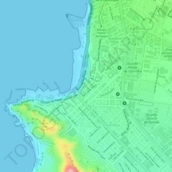
Name: Parque Manuel Cuadros topographic map, elevation, terrain.
Average elevation: 115 ft
Minimum elevation: -3 ft
Maximum elevation: 551 ft
Make a donation
Gear up for your next adventure:
As an Amazon Associate, this site earns from qualifying purchases at no extra cost to you.
Other topographic maps
Click on a map to view its topography, its elevation and its terrain.
Morro Solar
Perú > Lima > Chorrillos
Por su elevación, los cerros que circundan el Morro Solar son actualmente utilizados para la instalación de antenas retransmisoras de los canales de televisión y de algunas radios de Lima.
Average elevation: 125 ft
Make a donation
Gear up for your next adventure:
As an Amazon Associate, this site earns from qualifying purchases at no extra cost to you.