Geolocate

Les Angles topographic map

Click on the map to display elevation.

About this map

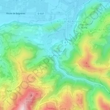
Name: Les Angles topographic map, elevation, terrain.

Location: Les Angles, Argelès-Gazost, Hautes Pyrenees, Occitania, Metropolitan France, 65100, France (43.07399 -0.01578 43.09337 0.02405)

Average elevation: 1,736 ft

Minimum elevation: 1,319 ft

Maximum elevation: 2,612 ft

Other topographic maps

Click on a map to view its topography, its elevation and its terrain.

Darré Peyrahitte

France > Occitania > Hautes Pyrenees > Lies

Average elevation: 2,274 ft

Hautacam

France > Occitania > Hautes Pyrenees > Beaucens

Average elevation: 4,875 ft

Lesponne

France > Occitania > Hautes Pyrenees > Bagnères-de-Bigorre

Average elevation: 3,294 ft

Madiran

France > Occitania > Hautes Pyrenees > Madiran > Madiran

Average elevation: 600 ft

Sedons

France > Occitania > Hautes Pyrenees > Viger

Average elevation: 1,775 ft

Asmets

France > Occitania > Hautes Pyrenees > Boô-Silhen

Average elevation: 1,791 ft

Galade

France > Occitania > Hautes Pyrenees > Campan

Average elevation: 3,369 ft

Gear up for your next adventure:

🔌Solar Panel Charger - Charge gear sustainably outdoors
🥇GPS Hiking Watch - Multi‑sport GPS watch with navigation and trail tracking
💧Water Purification System - Clean water on the trail with reliable purifiers
🪶Thermal Camp Blanket - Extra warmth for cold nights
📡GPS Antenna Upgrade - Enhance GPS reception in remote terrain

As an Amazon Associate, this site earns from qualifying purchases at no extra cost to you.