
Make a donation
Gear up for your next adventure:
As an Amazon Associate, this site earns from qualifying purchases at no extra cost to you.
Hampton topographic map
Click on the map to display elevation.
Make a donation
Gear up for your next adventure:
As an Amazon Associate, this site earns from qualifying purchases at no extra cost to you.
About this map
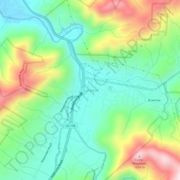
Name: Hampton topographic map, elevation, terrain.
Average elevation: 2,211 ft
Minimum elevation: 1,627 ft
Maximum elevation: 3,327 ft
Carter County trails, hiking, mountain biking, running and outdoor activities
Make a donation
Gear up for your next adventure:
As an Amazon Associate, this site earns from qualifying purchases at no extra cost to you.
Other topographic maps
Click on a map to view its topography, its elevation and its terrain.
Watauga Lake
United States > Tennessee > Carter County
According to the 2004 TVA River and Reservoir Operations Study, Watauga Lake is approximately 16.3 mi (26.2 km) long, with 104.9 mi (168.8 km) of shoreline. At the TVA summertime water level target "full pool", the lake surface covers 6,430 acres (26 km²) and the estimated depth of Watauga Lake is 265 feet…
Average elevation: 2,477 ft
Roan Mountain
United States > Tennessee > Carter County
Roan Mountain is located in northeast Tennessee at 36°11′39″N 82°4′6″W / 36.19417°N 82.06833°W / 36.19417; -82.06833 (36.194219, -82.068417). According to the United States Census Bureau, the CDP has a total area of 6.6 square miles (17.2 km2), all land. The elevation of Roan Mountain near…
Average elevation: 3,038 ft
Elizabethton
United States > Tennessee > Carter County
The elevation at Elizabethton Municipal Airport is 1,593 feet (486 m) ASL (the highest point of elevation in Carter County is at Roan Mountain with an elevation of 6,285 feet (1,916 m) ASL), and the airport is located on the eastern side of the city along State Highway 91 Stoney Creek Exit. Elizabethton is…
Average elevation: 1,860 ft
Roan Mountain
United States > Tennessee > Carter County
Roan Mountain is located in northeast Tennessee at 36°11′39″N 82°4′6″W / 36.19417°N 82.06833°W / 36.19417; -82.06833 (36.194219, -82.068417). According to the United States Census Bureau, the CDP has a total area of 6.6 square miles (17.2 km2), all land. The elevation of Roan Mountain near…
Average elevation: 3,038 ft
Make a donation
Gear up for your next adventure:
As an Amazon Associate, this site earns from qualifying purchases at no extra cost to you.
Make a donation
Gear up for your next adventure:
As an Amazon Associate, this site earns from qualifying purchases at no extra cost to you.
Elizabethton
United States > Tennessee > Carter County
The elevation at Elizabethton Municipal Airport is 1,593 feet (486 m) ASL (the highest point of elevation in Carter County is at Roan Mountain with an elevation of 6,285 feet (1,916 m) ASL), and the airport is located on the eastern side of the city along State Highway 91 Stoney Creek Exit. Elizabethton is…
Average elevation: 1,860 ft