Geolocate

Rosedale topographic map

Click on the map to display elevation.

About this map

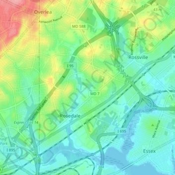
Name: Rosedale topographic map, elevation, terrain.

Location: Rosedale, Baltimore County, Maryland, 21237, United States (39.29906 -76.52976 39.36122 -76.47903)

Average elevation: 92 ft

Minimum elevation: -7 ft

Maximum elevation: 315 ft

Baltimore County trails, hiking, mountain biking, running and outdoor activities

Gear up for your next adventure:

🪑Ultralight Camp Chairs - Portable seating for resting after a long day of mapping
🧥Men's Rain Shells - Premium waterproof and breathable jackets for mountain weather
🪄Magnetic Compass - Accurate compass for navigation
🪵Folding Camp Saw - Compact saw for wood and campsite work
🧺Microfiber Travel Towels - Compact and fast-drying towels for trail use

As an Amazon Associate, this site earns from qualifying purchases at no extra cost to you.