Geolocate

Tampo topographic map

Click on the map to display elevation.

About this map

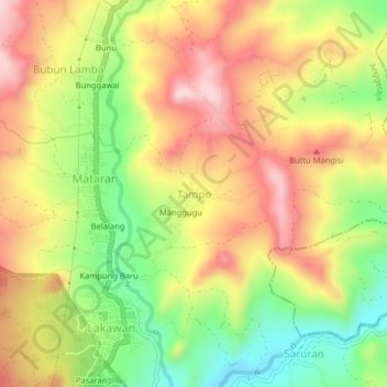
Name: Tampo topographic map, elevation, terrain.

Location: Tampo, Enrekang, South Sulawesi, Sulawesi, 91752, Indonesia (-3.41664 119.78826 -3.37664 119.82826)

Average elevation: 1,860 ft

Minimum elevation: 1,296 ft

Maximum elevation: 2,385 ft

Other topographic maps

Click on a map to view its topography, its elevation and its terrain.

Malua

Indonesia > South Sulawesi > Enrekang

Average elevation: 2,326 ft

Alla

Indonesia > South Sulawesi > Enrekang

Average elevation: 3,402 ft

Baraka

Indonesia > South Sulawesi > Enrekang

Average elevation: 2,713 ft

Buntu Batu

Indonesia > South Sulawesi > Enrekang

Average elevation: 4,787 ft

Bungin

Indonesia > South Sulawesi > Enrekang

Average elevation: 4,062 ft

Cendana

Indonesia > South Sulawesi > Enrekang

Average elevation: 499 ft

Maiwa

Indonesia > South Sulawesi > Enrekang

Average elevation: 702 ft

Malua

Indonesia > South Sulawesi > Enrekang

Average elevation: 2,326 ft

Gear up for your next adventure:

💧Water Filtration Bottles - Safely drink from streams and lakes while exploring
🧣Hiking Neck Gaiter - Multi‑use neck protection for outdoor weather
🥄Camping Utensil Set - Lightweight utensils for outdoor meals
🪶Paracord Bracelet - Survival bracelet with built‑in tools
🌐World Map Poster - Decorative world maps with topographic info

As an Amazon Associate, this site earns from qualifying purchases at no extra cost to you.