
Mabote topographic map
Interactive map
Click on the map to display elevation.
About this map
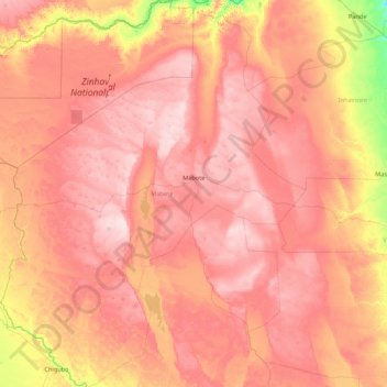
Name: Mabote topographic map, elevation, terrain.
Location: Mabote, Inhambane Province, Mozambique (-22.90577 33.16116 -21.30239 34.63421)
Average elevation: 443 ft
Minimum elevation: 56 ft
Maximum elevation: 719 ft
Other topographic maps
Click on a map to view its topography, its elevation and its terrain.
Mathale
Mozambique > Inhambane Province > Tome
Mathale, Tome, Funhalouro, Inhambane Province, Mozambique
Average elevation: 240 ft