
Giddings topographic map
Interactive map
Click on the map to display elevation.
About this map
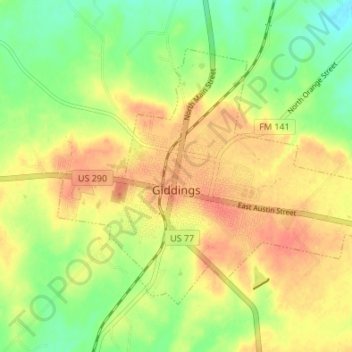
Name: Giddings topographic map, elevation, terrain.
Location: Giddings, Lee County, Texas, 78942, United States (30.16399 -96.95943 30.20649 -96.89187)
Average elevation: 463 ft
Minimum elevation: 381 ft
Maximum elevation: 528 ft
Other topographic maps
Click on a map to view its topography, its elevation and its terrain.
Lincoln
United States > Texas > Lee County
Lincoln, Lee County, Texas, 78948, United States
Average elevation: 384 ft
Dime Box
United States > Texas > Lee County > Dime Box
Dime Box, Lee County, Texas, 77853, United States
Average elevation: 364 ft