
Orani topographic map
Interactive map
Click on the map to display elevation.
About this map
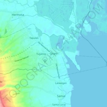
Name: Orani topographic map, elevation, terrain.
Location: Orani, Bataan, Central Luzon, 2112, Philippines (14.76122 120.49620 14.84122 120.57620)
Average elevation: 36 ft
Minimum elevation: 0 ft
Maximum elevation: 295 ft
Other topographic maps
Click on a map to view its topography, its elevation and its terrain.
Lupang Hinirang
Philippines > Bataan > Orani > Tugatog
Lupang Hinirang, Tugatog, Orani, Bataan, Central Luzon, 2112, Philippines
Average elevation: 33 ft
Sibul
Philippines > Bataan > Orani
Sibul, Orani, 1st District of Bataan, Bataan, Central Luzon, 2112, Philippines
Average elevation: 466 ft