
Wieliczka topographic map
Click on the map to display elevation.
Wieliczka
The town lies in a valley between two ridges that stretch from west to east: south Wieliczka foothills, north Bogucice sands, including the Wieliczka-Gdów Upland. The south ridge is higher, while the northern ridge leads to national road 94. Near the town lies the A4 highway (E40 European route), which connects Kraków with Poland's south western and south eastern regions. Despite the small area, the city's relative altitude accounts for more than 137 –m–: the highest mountain reaches 361,8 metres above the sea, and the lowest point lies at an altitude of 224 metres above sea level.
About this map
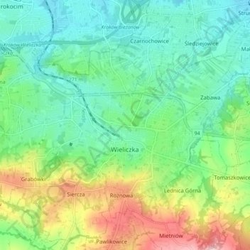
Name: Wieliczka topographic map, elevation, terrain.
Average elevation: 886 ft
Minimum elevation: 666 ft
Maximum elevation: 1,381 ft
Other topographic maps
Click on a map to view its topography, its elevation and its terrain.
966
Poland > Lesser Poland Voivodeship > Wieliczka County > Lednica Górna > Świdówka
Average elevation: 1,165 ft